


Trois becs

Monjean
User
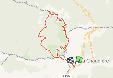

Length
10.8 km

Max alt
1565 m

Uphill gradient
808 m
Km-Effort
22 km

Min alt
1026 m

Downhill gradient
812 m
Boucle
Yes
Creation date :
2020-06-14 07:16:59.787
Updated on :
2020-06-14 14:36:00.586
5h59
Difficulty : Very easy

FREE GPS app for hiking
 SityTrail
IGN / Geographical institutes
SityTrail Plus
The world is yours!
About
Trail Walking of 10.8 km to be discovered at Auvergne-Rhône-Alpes, Drôme, La Chaudière. This trail is proposed by Monjean.
Positioning
Country:
France
Region :
Auvergne-Rhône-Alpes
Department/Province :
Drôme
Municipality :
La Chaudière
Location:
Unknown
Start:(Dec)
Start:(UTM)
674905 ; 4944196 (31T) N.
Comments